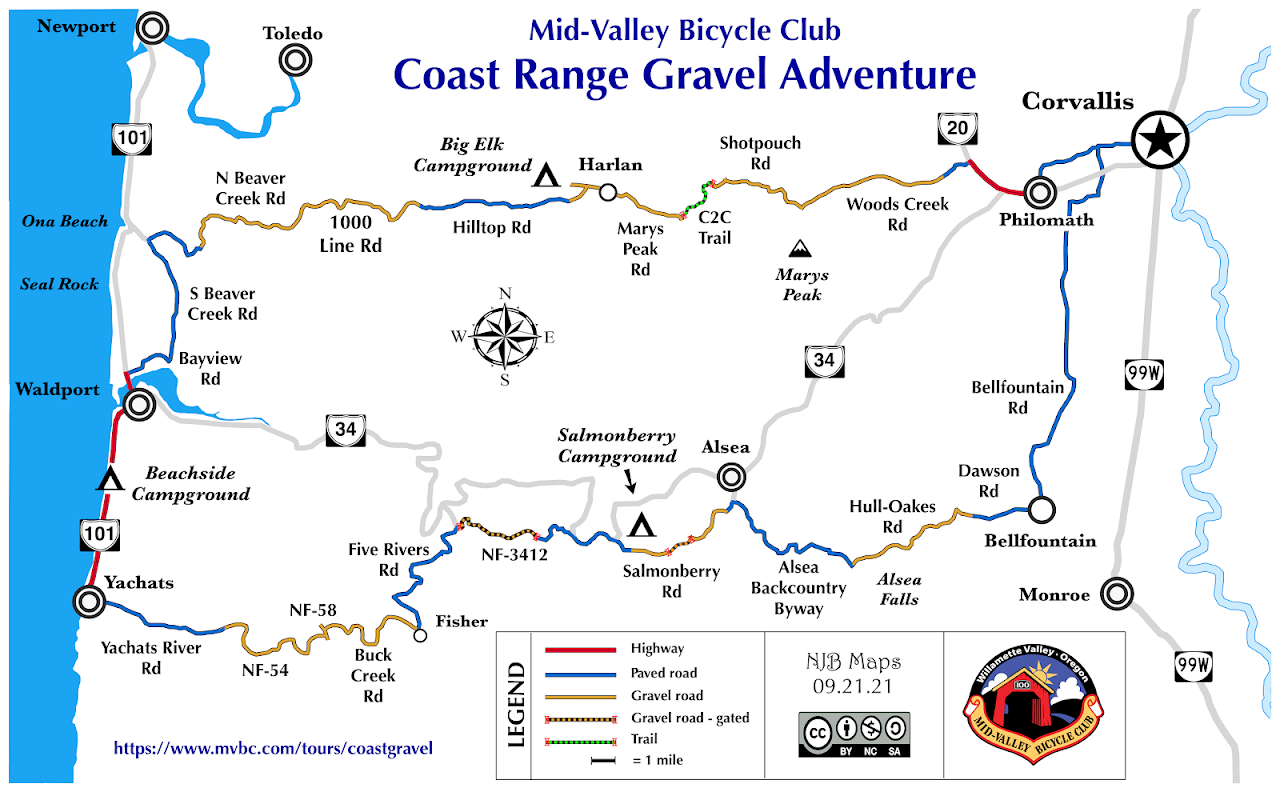
Day 1
We take familiar streets to Philomath where we then take Hwy. 20 for a couple of miles to the turn off at Woods Creek Road. This is where the adventure begins as Woods Creek Road soon turns to gravel and starts climbing the flanks of Mary's Peak. At the parking area and trailhead we reach the highest point of today's ride at about 1800'. Here we begin following the signs for the C2C trail. We drop and climb again several times, with some fantastic views before dropping down to Shotpouch Creek. We then climb a bit more and cross a gate onto National Forest land before dropping down again to Sugar Bowl Creek. Here we are on purpose built single track for a short section and then eventually come out on Mary's Peak Road, which takes us to Harlan. A couple of miles further on Harlan Road and we get to Big Elk Campground.
Day 2
From Big Elk CG we backtrack about a mile to Grant's Creek Road which takes us to Hilltop Road. Hilltop Road is a paved single lane logging road which treats us to some serious climbing and spectacular views. Eventually we hit gravel again and begin our descent on North Beaver Creek Road. We hit the coast at Ona Beach. Last year we then headed down Hwy. 101 to Waldport, but this year we may try South Beaver Creek Road. Either way after Waldport it is another 4 miles to Beachside State Park.
Day 3
We continue down 101 to Yachats where we'll probably stop for a second breakfast before leaving the coast and heading up the beautiful Yachats River Valley. After 8 miles or so we're back on gravel to the end of the valley, and then a couple of miles of steep climbing on a logging road. Then comes a nice long gravel decent down Buck Creek to the Five Rivers Valley. Here we hit pavement again for a few miles before tuning up NF road 3412. This was a new discovery last year that avoids a long stretch of Hwy. 34. First we climb for about 3.5 miles on nice gravel to the top, and then another swooping 3.5 miles downhill on smooth single lane pavement. Here we hit Hwy. 34 for a couple of miles on to Salmonberry Campground.
Day 4
From Salmonberry CG we continue south on Salmonberry road through a gate and up into Starker forest land. It's a moderate climb over a few miles up and over and then out Haines road to Deadwood highway. We take a short detour into Alsea for a second breakfast, and then it's up the South Fork of the Alsea towards Alsea Falls. We never actually get to the falls as we get back on gravel and take Hull Oakes down to Dawson Mill and then Bellfountain Park. Finally its a cruise home on Bellfountain road.
Note: MVBC club members have access to Ride With GPS routes for all four days.